Tuesday, March 18, 2014

The Old State Capitol of Georgia

This Gothic Revival beauty stands after 200 years in a small east Georgia city. Photo by me, November 2012.

This was parts unknown for me in the Fall of 2012 as I traveled south on U.S. 441, crossed Lake Sinclair and arrived in Milledgeville. Other than Augusta I had never been or passed through the east central part of the state. It was a pretty drive south past the farm lands as I traveled from Interstate 20 with the occasional hill and town but mostly wide open spaces on the way to one of the former state capitals of Georgia. Georgia has been around long enough, a British colony in 1733 and a state since 1788, to have had more than one capital city - we Georgians can be a fickle bunch. I live in the current capital so on that perfectly sunny and warm October day I wanted to see the one that preceded Atlanta.

Before state lawmakers took residence under the gold dome in Atlanta this was their home. Photo by me, November 2012.

In 1804 the Georgia legislature voted to permanently relocate the state capitol from Louisville to Milledgeville. Construction began in 1805 for the new state capitol building in Milledgeville and it opened in 1807. It turned out to be not so permanent as Atlanta became the state capital in 1868.  

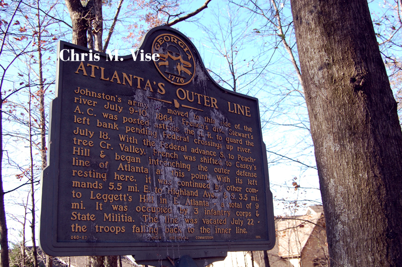
It was also here that the Georgia legislature made its most tragic mistake in its history in January 1861. The convention to secede from the Union over slavery was held in this building. It was not an immediate decision and several votes were held as legislators were divided among those in favor of secession and those who were Union loyalists. One vote was as close as 166 to 130 in favor of secession, but the final vote in favor was 208 to 89. 

Despite what might be taught, portrayed in the media or people may believe, the South and its citizens are and were not a monolithic block. After the legislature's vote and during the American Civil War there were protests, riots, desertions, militias loyal to the Union formed and a distaste against the war among some of the populace in Georgia. Demands to put the secession to a vote by the people of the state were ignored by those in power. As one newspaper in South Georgia put it, "this has been a rich man's war and a poor man's fight." Fools who still today fly the Confederate battle flag or erect monuments have never spoken for all of us in the South and likely understand very little of this region's complex history the same as those outside the region who believe in stereotypes.  

Photo by me, November 2012

Architecturally, the building was different from most state capitol buildings of that period in that it did not have a domed roof. The Gothic Revival building looks more like a fortress or castle than what comes to mind when one thinks of capitol buildings. I quite like it. Instead of a dome it has a pointy clock tower in the center. The lancet arch windows are elegant and the arch is repeated again on the face of the clock tower.

Photo by me, November 2012

Originally budgeted to be built for $60,000 by the time is was finished with additional wings added and renovations it cost $200,000 to complete or $5.2 million in 2012. Though the building was occupied in 1807 by the legislature, it would not be finished until 1835 and today what you see is considered to be the finished product. The building is made of brick that was manufactured in Milledgeville. The walls are reportedly between three to four feet thick.

The crenelations along the roof line add to the look of the building appearing as a fortress or castle. Architect Henry Hamilton is responsible for the crenelations and the two additional wings added to the building in 1828 and 1834.

The north portico that faces out onto Greene Street. Photo by me, November 2012.
The west entrance and stairs to the building. Photo by me, November 2012.
The south portico. Photo by me, November 2012.
The east face of the building. Photo by me, November 2012.

The granite stairs and the porticoes were added to the building in 1835. These additions to the building were designed by Charles Cluskey. Based on illustrations I have seen of the building prior to the steps and porticoes being added it would appear that one would have entered the building one level below from the floor you enter today.

Satellite imagery from Google Maps.
In this satellite view you can see how the capitol building was built in the middle of the square and was originally surrounded by green space on all four sides. This was a fairly conventional landscape design during the time for capitol grounds. Milledgeville like Savannah was planned out with squares and with a gridded street layout.
Photo by me, November 2012.

This is one of the sidewalks leading out from the capitol building in a linear line. This one heads in the direction of South Wayne Street. The lamps posts provide a nice visual aide in guiding the eye off into the distance, I bet they look nice at night.

The old state capitol building looks marvelous today but it has been beset by many unfortunate occurrences. You could say the building might be cursed - it suffered a fire in 1833 to the roof,  an 1894 fire in the clock tower, and in 1941 it had a serious fire from faulty wiring that did extensive damage. Another $8,000 in damage was done when Sherman passed through on his March To The Sea campaign during the American Civil War.

In 1871 the building served as the Baldwin County Courthouse and in 1879 it became the property of the Middle Georgia Military and Agricultural College which was later changed to the Georgia Military College in 1900. The building today is still the central piece of their campus.

Photo by me, November 2012.

Photo by me, November 2012

These are other buildings that are a part of the Georgia Military College campus. The buildings occupy space on the former capitol grounds and mimic the architectural style of the old capitol building. You can visit the old capitol building which today houses classrooms, a museum and still contains the house chamber from when it was the State Capitol Building of Georgia. 


For a historical perspective here are a couple of photos of the college's football team.

1907. Image courtesy the state archives of Georgia.

And from 1940. Image courtesy the state archives of Georgia.

And of the cadets in uniform before the old capitol.

1887. Image courtesy the state archives of Georgia. 
   

1915. Image courtesy the state archives of Georgia.

One final historical photo from 1941 looking through the gates which are still there today.

1941. Image courtesy the state archives of Georgia.

Thursday, March 6, 2014

Casey's Hill

The view from Casey's Hill in Atlanta looking northwest to Vinings and Smyrna in Cobb County. Photo by me, November 2013.

High on what might be the highest point in the city is a little known spot that once was an important place in Atlanta. As over a century has passed and the city has grown faster than fertilized kudzu this quiet place has been mostly forgotten and slowly encroached upon by development. At just over a thousand feet above sea level you can see well northwest into Cobb County on a clear day. In the distance are the buildings from the Cumberland, Galleria and Vinings areas. That high vantage point is one of the reasons this ridge is important to Atlanta. The other reason it has historical significance is for the man who lived and died here. Internet searches will not reveal much about Casey's Hill outside of a few mentions on American Civil War sites and I was unaware this place existed until I explored neighboring Crest Lawn Cemetery. Just as I was when I was a rural boy, curiosity had me wondering what was at the top of the wooded hill. I decided to find out.


Photo by me, November 2013.

As the city, then known as Terminus in 1837, was being born between two railroads, the Casey family settled in and began helping build the rail network that spawned it. John A. Casey moved to Terminus in 1838 and contracted the grading and construction of the Western and Atlantic railroad. Fulton County did not come into existence until 1852, but was a part of DeKalb County when Casey arrived. By the time of his death in 1907, John A. Casey was heralded in his obituary as the oldest living settler of Fulton. It was said that kept within the family they retained the broadax that hewed the first railroad cross tie laid, if true, I wonder what became of that.

1928 Topographical map from the City of Atlanta Mapping Division.

Casey settled on this hill northwest of the zero mile marker, along the old Marietta Road and built his home. He would father eleven children which by today's standards sounds incredible but back then large families were common in the United States. In addition to railroads he became a justice of the peace and according to his obituary was referred to as "Squire Casey." He was said to have stayed mentally sharp until his death and was buried on this hill.

Photo by me, November 2013.


The old Marietta Road ran through here and was an important connection between Atlanta and Marietta. Once a traveler crossed Casey's Hill heading north it was downward to the Chattahoochee River and across via Montgomery's Ferry. This connection and the higher elevation than that of the surrounding terrain made Casey's Hill an important strategic spot in the defense of Atlanta during the American Civil War. Three Confederate infantry corps along with state militia formed the outer defenses of the city on this hill. With advancing Union troops, the Confederates fell back to the inner lines in July 1864. Atlanta was captured by General Sherman in September of that same year beginning his March to the Sea campaign.

The road leading up Casey's Hill. Photo by me, November 2013.

Other than two historical markers there is no evidence that a war was once fought here. There are no cannons and no visible trenches that I found. What remains today are the mostly untended graves in the cemetery atop the hill adjacent to Crest Lawn Cemetery. While Crest Lawn receives perpetual care that is not so for the graves on Casey's Hill. The graves here nestled among the trees, vines and leaves are mostly forgotten. Without the occasional cleaning and maintenance of surviving family members and volunteers, Casey's Hill would eventually become by the forces of nature. 

Photo by me, November 2013.

The top of the hill has a park-like quality high above the noise of the city and under an older tree canopy. Ivy vines and brush have rooted their way in and some of the headstones are losing the battle to nature.

Photo by me, November 2013.


Photo by me, November 2013.

Photo by me, November 2013.

The gravestone reads:
A light from our household is gone.
A voice we loved is stilled.
A place is vacant in our hearts
That never can be filled.

It was the day after Thanksgiving in 2013 when I visited. Many people were fighting for Black Friday deals, but I strolled through some city history under the blue sky and cool temperatures.  I had the cemetery to myself, at least among the living.

Photo by me, November 2013.
 
Photo by me, November 2013.


Some old stone works surrounds these graves. The unique tree headstone dates back to 1890 and the smaller one is from 1894.

Photo by me, November 2013.


This aerial photograph shows how rural the area surrounding Casey's Hill was in 1938. Crest Lawn Cemetery is on the right and Casey's Hill is roughly in the center of the photo.


The most recent aerial photograph from Google Maps shows just how development has surrounded Casey's Hill and Crest Lawn Cemetery.

Today development has come within a few feet of Casey's Hill and claimed part of it except for the area containing the cemetery. A large portion of the hillside abutting the cemetery was excavated and you could almost step out from the cemetery onto the roofs of some of the houses. In other areas where the houses were built level with the cemetery you could stand at a grave and touch the side of a house. There was no fencing or protection between the cemetery and the housing development.

Wednesday, March 5, 2014

The Side of the Sound Table


Photo by me, November 2013.


Murals are something Atlanta is blessed with thanks to organizations like Living Walls. You can even on the grayest of days find hope and energy in the colorful work of artists from all over the world that have been brought here to brighten our blank walls. I enjoy photographing them because it takes me to all parts of the city and corners I've never been to before. Street murals have the ability to draw us in, have us stand and contemplate them for awhile, evoke an emotion and satisfy us as other forms of artistic expression will do.


There's plenty to admire and consider on this wall. Photo by me, November 2013.

The murals on the side of the Sound Table can be seen coming east on Edgewood Avenue and north/south on Boulevard in the Old Fourth Ward. In some ways it is a bit hard to figure them out. First there is the advertisement for local artist Radcliffe Bailey which is the head on the left side coming through the pieces of wood and where the word 'High" is located. Second is the 2012 mural from Argentinian artist JAZ which is the two riders on horses that are seemingly mirrored and blending together. The third is the work of French artist Roti painted in 2013, which is the whale, the structures in gray and the playful hands pinching the head from the advertisement and the other holding an eye.

Cadavre Exquis or exquisite corpse. Photo by me, November 2013.

Roti had the chance to start with a blank wall for his work by covering over the existing murals but chose not to do so and took on the challenge of making his interact with the others. He decided his mural would be based on the parlour game Exquisite Corpse. The game is based on multiple players drawing a collage in turns overlapping one another on a sheet of paper folded in quarters. That game is also a derivation of the game known as Consequences which utilizes words instead of drawing. Roti's idea was genius in creating the wall that we see today which does resemble a collage created by multiple artists. His inspiration for using a whale was that it is the largest mammal and every year despite its travels it will return to the same spot. He calls the whale the mother and says that it supports everything.

You can read an interview with Roti and other Living Walls artists in this piece in Burnaway.

Friday, December 13, 2013

Sunrise of Edgewood

Photo by me, November 2013

Walking along the streets of the Old Fourth Ward you can see any number of murals with a variety of styles and messages. This one called The Sunrise of Edgewood by Gaia and Nanook is the most vivid and eye catching. The mural arrests your attention and since it faces an open gravel lot you can easily see and admire it walking east on Edgewood. The mural was commissioned by Living Walls and was produced in 2012. The man's face in the mural is aptly round and has a warm orange and red tone mimicking that of the sunrise. The day I went to view it was a cloudy Fall day and it had the effect of brightening up the neighborhood.

Gaia is based in New York and has painted dozens of murals around the world. Nanook is based in Baltimore and has a portfolio of murals as unique and colorful in locations around the globe too.

Sunday, December 8, 2013

The Grant Park Overlook

August 11, 2013

Left to decay on property leased to zoo Atlanta is this wonderful brick and granite overlook in Grant Park. It is a shame that the zoo is allowed to let this decay into the past with no maintenance as this structure belongs to the citizens of Atlanta. If the zoo is fencing the area off and leasing city owned property it should be required to care for this overlook and maintain it in the event that in the future the area is returned to the public. This was once the main entrance to the park from Cherokee Avenue and you could stand on the overlook and view what was Lake Abana. However today, you would hardly even know it exists underneath the vines, weeds and trees taking it over.

Photo by me, August 2013


As you can see the zoo it allowing nature to run wild over it with weeds and even trees are growing out of it. The overlook sits at the intersection of Cherokee Avenue and Ormond Street behind the Erskine Fountain which was moved to this entrance of the park in 1912. I see no reason for the public to not be allowed to walk out on the overlook even if the view is not the same. The zoo is not using it and only neglecting it so why not open it back up to the public? Visitors to the neighborhood and park could utilize the space and the city could maintain it.

Photo by me, August 2013

Before too long this piece of Atlanta's history will not be able to be saved. Grant Park, which is Atlanta's oldest park, seems to get neglected. It is odd that Piedmont Park gets so much attention and care but not so for Grant Park. In doing some reading it seems the overlook was sealed off from public use some time between 1988 to 1997. Since then it has been left abandoned and abused.

Grant Park Master Plan 2008
In a master plan that I found on the website for the Grant Park Neighborhood Association it calls for the re-opening and restoration of the overlook for public usage. It is nice to see that others are also interested in seeing this saved and opened back up for public use. Yet, that was five years ago and nothing has happened.

Saturday, December 7, 2013

Finding Miss Daisy

Photo by me, November 2013

High on a hillside in Crest Lawn Cemetery in the Bolton neighborhood of Atlanta rests a woman who became posthumously famous. It's well known that Driving Miss Daisy is set and filmed in Atlanta and is based on a true story. The main female character is played by Jessica Tandy in the movie version based on the 1987 play by Alfred Uhry. That character is based on the grandmother of Uhry, Lena Fox. Other than what you see in the movie very little is known about Lena Fox, she lived in a time before the internet existed and she wasn't famous when she was alive so that is to be expected.


Photo by me, November 2013

She did live a long life, that much is known, she died five months before her 96th birthday. Her actual house, not the one used in the movie for filming, is at 1284 Fairview Road in Druid Hills and is for sale. The Lullwater Road house used for filming the movie also has been up for sale in 2013 for roughly two million dollars.

Photo by me, November 2013


She is buried alongside her husband, Alfred. He died at the young age of 55.

Wednesday, December 4, 2013

Nobody

Photo by me, November 2013

Of all the murals I've seen this year the Nobody mural in Castleberry Hill by Axel Void is my favorite. From looking through his other works he seems to do mostly a dark theme or style in his imagery. Nobody seems to go along with the darkness too, from his choice of colors to having the boy missing an eye. The boy could have his eye closed I suppose but for me it appears to be entirely missing. The mural was commissioned by Living Walls in 2013.

Monday, November 4, 2013

Renaissance Of The City By Robert Helsmoortel

Renaissance Of The City by Robert Helsmoortel

A curious thing today I noticed while reading a history on the renovations of Peachtree Center from the 1960s through the 1980s I noticed a public sculpture of art had gone missing or at least missing from the public eye.The large commissioned piece by Robert Helsmoortel from 1965 seems to no longer be on public display or even in existence as far as I can find. I can't remember ever seeing Renaissance Of The City anywhere and it certainly isn't there today in front of 230 Peachtree Street. If it exists on public display I don't know where and can only wonder if it was sold off to a private collector or is in storage somewhere. I would like to see it if anyone knows where it might be.

Thursday, October 24, 2013

Inman Park Festival 2013


Photo by me, April 2013.

By the time Spring is usually well underway in Atlanta comes one of the better arts festivals in the city, the Inman Park Festival in April. The festival takes place over a weekend and features the standard booths of artists selling their creations, a spirited parade, live musical performances and a tour of homes in the neighborhood, which I sadly missed this year. This festival is hugely popular in a city that features so many arts festivals and street fairs from Spring into Fall. Of all the arts festivals this one is my favorite for it takes place in such a wonderfully historic location at a time of the year when Atlanta is coming alive with the colorful blossoms of nature.

The history of Inman Park is that it was  established in 1890 by Joel Hurt. It is a neighborhood of fine homes on curving streets and interspersed parks. Joel Hurt made his fortune in real estate development with the Atlanta Building and Loan Association and later co-founded the Trust Company of Georgia. Inman Park was a streetcar suburb on the edge of the city then instead of the in-town neighborhood we consider it to be today. The streetcar line, also owned by Hurt, was the Atlanta and Edgewood Street Railway Company and it began service in 1886. Inman Park is considered the first suburb in Atlanta even though it resembles nothing of what we would consider suburb today. Inman Park was named after another legendary Atlanta businessman Samuel M. Inman. Despite how grand and expensive Inman Park may seem today there was a period of decades beginning in the 1950s when the neighborhood went into decline. During that time many of the large homes were subdivided into apartments and poverty and crime was commonplace which seems hard to imagine now walking through the neighborhood. In the 1970s the neighborhood began to turn around and restoration and investment began to bring the neighborhood back from its decline. Our city is very fortunate to still have this neighborhood for the residents of today to admire.

Photo by me, April 2013.

Photo by me, April 2013.
A group dressed as garden gnomes in the parade. Photo by me, April 2013.
After the parade one of the floats decided to keep performing for the crowds. Photo by me, April 2013.
A band performs in Delta Park, one of the parks in the neighborhood. Photo by me, April 2013.

An example of one the many beautifully restored homes in the neighborhood. This one is on Edgewood Avenue. Photo by me, April 2013.
Spring in Inman Park. Photo by me, April 2013.

Photo by me, April 2013.

We stopped like many others to enjoy the grass and a beer on this Spring day in one of the parks in the neighborhood. This particularly large park is on Euclid Avenue. Like I always say, it seems like you can never escape the Bank of America tower in this city. It is so tall that you can see it from so many places and I was surprised to see it from here.

Photo by me, April 2013.
One of my favorite beers is SweetWater Blue from the SweetWater Brewing Company. SweetWater is also a local Atlanta brewery so I'm glad to support them.

Photo by me, April 2013.

Photo by me, April 2013.

Photo by me, April 2013.

Photo by me, April 2013.

Maybe the most notable landmark in the neighborhood is the Trolley Barn on Edgewood Avenue. The barn which opened in 1889 was a housing and maintenance facility for Atlanta's first streetcar line. The barn is currently owned by the City of Atlanta and managed by a private company. The city bought the building in 1976 and had it restored by 1987. Prior to that, the building had fallen into disrepair and decline much like the neighborhood had at that time. Today it houses special events, parties and weddings. Very recently there has been some discussion that the city may sell the building. On the day I attended the festival, a dance troupe was performing in it for the festival attendees.

Inman Park United Methodist Church. Photo by me, April 2013.
Above is the Inman Park United Methodist Church. The main sanctuary was constructed in 1898 of granite from Stone Mountain. It is of the Romanesque style and was designed by Willis Franklin Denny, II who also designed Rhodes Hall. The similarities between the two buildings can certainly be seen.

The dates for the 2014 festival are April 25-27 and I hope to do it again next year and the year after.