Showing posts with label Alabama. Show all posts

Wednesday, January 22, 2025

The White, Cold Heart of January

A snowy view from the second floor of my house. Photo by me, January 2025.

It was only supposed to be flurries here and it mostly was for over three hours, but the atmosphere was so dry that it became a high ratio snow and it gushed. At the three in the afternoon the snowfall began it was twenty-three degrees with a dewpoint of twelve and those were unusual circumstances to produce snow around here. A typical snow here is one with a high moisture content, produces big and fat flakes, is sloppy, heavy and occurs under conditions with temperatures in the low thirties and dewpoints in the upper twenties to low thirties. Yesterday, the conditions were different with an Arctic airmass in place and the snow was dry and productive. It has been a few years since a snow of this type occurred here and when it does, it creates havoc with quick accumulations that land on roadways turning them quickly into sheets of hard ice.

Photo by me, January 2025.

Photo by me, January 2025.

The storm's arrival at rush hour stranded people on the untreated roads over the hilly terrain of this area. Cars unable to climb these icy hills  were abandoned and if people were close enough to home they walked the remainder of the way. I observed many stunned and bone chilled cold people on foot coming up my hill from the river on a road that has no sidewalks, but plenty of curves.


If you are a native to northern Georgia, like I am, then you will remember the similar scenario that occurred on January 12, 1982 and it was called SnowJam! I was a couple of months shy of turning nine, but that was a fun storm as a kid and a horror show for adults. In some ways, it is reassuring to think that as much as life has changed in those forty-three years, that we Georgians make getting stuck in the snow a memorable adventure.

Photo by me, January 2025.

Photo by me, January 2025.
 

This was a minor snow here, amounting to an inch, that was a big headache for some. So far this winter, there have been five inches of snow here and within a short period of only eleven days between two storms in the white, cold heart of January. This is above average and compared to the two previous winters there was no snow, not even a flurry.


The cold has been exceptional too. This morning it was eleven degrees here and three degrees above zero in the mountain valley town of Blairsville. The U.S. Forest service stations at Cohutta dropped to six degrees and the one at Brasstown (not to be confused with the state's highest peak, Brasstown Bald) achieved four degrees. The temperature was below freezing here from 6PM Sunday to 1PM Wednesday for a total of sixty-seven straight hours. We reached a high this afternoon of thirty-four for only a couple of hours.

The U.S. snow depth map for January 22, 2025. Courtesy NOAA.

Aside from the cold, the most impressive aspect from a regional perspective was the record breaking snow from the southern tip of Texas, along the Gulf Coast and South Atlantic Coast. For most in the coastal areas this truly was a once in a lifetime storm and in some places it was record shattering.

Today's visible satellite imagery showing the snowfall through southern Alabama, northern Florida, Georgia and South Carolina.

New Orleans received over nine inches breaking a record from 1963 by seven inches.

Mobile, Alabama saw eight inches.

Snow meets beach on the Florida Gulf Coast.

Pensacola Beach, Florida had seven and a half inches.

The small southwest Georgia town of Camilla accumulated eight inches.

Milton, Florida broke the state record for the most snow ever with 8.8 inches.

Savannah reported three inches of snow, but I suspect most of it was probably sleet.

This was a rare storm in that areas further to the south saw more snow than areas of the region to the north. Atlanta's record was not so impressive as it snows there more often than the other places listed. Atlanta broke the daily record  for January 21st from 1983 with 1.1 inches. I was ten at the time and do not have any particular memories of that snow, which was probably more where I lived in the northwest part of the state. We may have called that SnowJam 83! as every snowstorm after 1982 for several years was called SnowJam!


Wednesday, June 21, 2023

What Is Between What Is Out There


Birmingham, Alabama. Photo by me, June 2023.


The road has had more of my time this year like an old friend calling me on the phone for a long catch-up conversation. I am not good at ending conversations; I am bad at knowing when to wrap things up and have to let the other person do it when the pauses grow too long. Every conversation could be the last and it should count for something, as I see it. For those who have endured the hours-long phone conversations with me, they deserve to be appreciated. 


I like being on the road, watching the sunset between the white stripes of a rest area parking lot, not caring all that much about a place, after all, I am only passing through and watching the crazies tailgate each other in the fast lane. I am not ready to end the conversation with the road, hang up and say, "Bye-bye." I want to see what is out there and what is in between what is out there. I have had a lot of long drives and conversations in my lifetime.

The Birmingham skyline. Photo by me, June 2023.


I was in Birmingham, Alabama two weeks ago. Small to mid-sized cities are time capsules of the past. They remind me of Atlanta in the 1980s and 90s, before traffic reached twenty-four-hour gridlock and all of the cool places and people were priced out. Small cities have just enough of the ingredients of the magic of possibility to not bore me without overwhelming me.


The car radio scanned and I was surprised that Birmingham had an alternative station, 107.3 FM Mountain Radio. I listened through the eastern suburbs and spent the rest of my time in the city listening to a classic rock station that played too much AC/DC. Back in Black greeted me as the skyline came into view. My mind veered to the early 1980s and I was hearing that music coming from my brother's bedroom and it seemed angry in the way teenagers pose as rebels against everything.


I have a little history with the city and plenty with the state of Alabama. Alabama, contrary to popular opinion, is not a foreign country for gays. The gays there are the rebel weed dandelions growing through the sidewalk cracks and surviving through the adversity of existence. In the 2000s, I occasionally partied at a club called Quest. It was one of the few gay bars in the city and in the state and it was open 24 hours. The attraction was that it was always open, never closed, and open later than the Atlanta bars that closed at three in the morning. These trips were never planned and were spur-of-the moment excursions. I visited a few times danced until sunrise or so, grabbed a hotel room to crash for a few hours and went to The Galleria mall to buy fresh clothes. The locals at Quest were friendly and recognized that I was not a local. I would say I was from Atlanta and that led to too many questions and unwanted offers to buy coke. I raised the guards and applied my fake bar name, Eric.


Birmingham. Photo by me, June 2023.


My reason for being in Birmingham this time around was to visit an antique store. The times have changed. The store was on the south side, in the same neighborhood as Quest. I parked on the street and walked on a windless, hot day as smoke from the forest fires in Canada glazed the sky. I relaxed and felt the relief of having more space around me than in Georgia. 


I smelled the stale scent of a time capsule opening.


Photo by me, June 2023.

It was a large and interesting store and a few purchases were made. The prices were better than what can be found in Georgia, another benefit of being a less populated place.


I loafed around Birmingham for the day, seeing new places, eating barbecue at Dreamland on 14th Avenue and then headed home to Georgia. The radio stayed on the classic rock station on Interstate 20 as far east as Anniston, another place with a history for me and radio and Susquehanna, until the static choked it out. The last song I heard was The Marshall Tucker Band's Can't You See


The road called, the conversation was had and I was out there seeing what was in between through the crackling static. The last of the sun fell on me at the Georgia welcome center parking lot. A family posed in front of the state sign with a peach on it. I must have looked as silly as them on some of my travels too. Life is going by the same as the cars on the asphalt and there is no slowing down.


Monday, January 28, 2019

Paint Me The Places You've Seen

Photo by me, January 2019.

Early yesterday as the sun rose on a frosty winter morning I was on the road. I melted the thick ice off my car windows and began driving from my home in Atlanta to my brother's house in northeastern Alabama. I am writing a book and our monthly meetings are informal interviews in front a fireplace, with cups of coffee and college football going in the background. I need his memories and his confirmations of mine.

I have made this two hour drive so many times in the last fifteen years since he moved there that I could do it in my sleep. Bored by the drive, I sometimes switch the route just to break up the monotony of the landscapes. I go one way and I avoid where I grew up in Paulding County, Georgia by driving around it. Of my choices of roads this is the preferred way.

I dislike the first parts of the drive as it leaves the city through the northwest suburbs of Atlanta and up to Cartersville, Georgia. Interstate 75 is a swollen mess of lanes, always in a hurry to get nowhere drivers and ugly scenery through Cobb County. The only beauty is the crossing of the Chattahoochee River caught in a brief glimpse as a stranger caught from the corner of an eye in a crowd.

My route from home to my brother's area.

After Cobb, the landscape changes from buildings, billboards and sprawl by the time I reach Lake Allatoona and Red Top Mountain in Bartow County to something more pleasing. Allatoona is where I swam, played with my plastic boats and loved the 1970s as a small child.

In Cartersville I exit the interstate and head north on old U.S. Highway 41, the road immortalized in the song Ramblin' Man by the Allman Brothers. Highway 41 was the precursor to Interstate 75 and was decades ago the main north/south route for northerners from the Upper Midwest headed to the sunny beaches of Florida. In my mind there is no other road that I identify more with the old Georgia that I used to know. Today it is a mostly commercial highway through metro Atlanta filled with endless traffic lights, fast food restaurants and shopping centers that could be outside any city in the country. 41 is an ugly scar.

I  am on Highway 41 only a few miles before merging onto U.S. Highway 411 north of Cartersville. This is the road that will take me north and to the west close to where I am headed in Alabama. This road is a lonely road of woods on rolling hills, the cold flowing Etowah River and pastures. I hope it stays that way and never changes. Miles onward, it skirts the city of Rome, Georgia in Floyd County and breaks south and west through Cave Spring, Georgia and scurries away into Alabama. The stretch of two lane road from Rome to Cave Spring is the highlight of this drive and the prettiest.

Northwest Georgia is known for its low topped ridges and valleys that are the final tails of North America's oldest mountains, the Appalachians. These are not the big mountains of the chain like those found in north central and northeast Georgia, but are more like grooves in the geological record. Having grown up in Northwest Georgia in what was then a rural area I feel very much at home passing through.

Topographical map of Vans Valley.

Vans Valley along Highway 411 between the community of Six Mile and the town Cave Spring is the most scenic stretch of the drive. It is a wide valley with grazing and crop land on the floor enclosed by two of those low topped ridges.

I have also seen this particular area spelled as "Vann's Valley" which I believe to be the correct spelling. The name is said to come from David Vann who lived here. Vann was a sub-Chief of the Cherokee Nation and was treasurer between 1839 through 1851. Vann was killed by Union supporting Pin Indians during the American Civil War in 1863.

Highway 411 follows the same road through the valley as it did when the Cherokees were forcibly removed from their land during The Trail Of Tears.

Photo by me, January 2019.

The road along the floor of the valley hugs the southeastern side. The area reminds me of the area in Tennessee where my father's family lived and farmed in the mid 1800s up to now. A picturesque world of bottom land and hills that pop up out of everywhere and nowhere. 

Photo by me, January 2019.

The eastern side of the valley and the ridges that enclose it.

Photo by me, January 2019.

A large estate can be seen looking to the western side of the valley. There are many nice homes through here and into the town of Cave Spring.

Leaving Vans Valley I enter Cave Spring. It is a town known for a cave, spring water, the Georgia School For The Deaf, antique stores and it is a speed trap if there ever was one. The cops aggressively enforce the ridiculously low speed limits that stretch too far. A person could walk through Cave Spring faster than they could drive through it.

Cave Spring is the last town in Georgia on my drive. U.S. Highway 411 veers due west from here and in a few miles crosses the state of Alabama line in the direction of Centre.


Photo by me, January 2019.


An old barn sits in another valley in Alabama. The scenery on my brother's road is the same as Northwest Georgia a few miles away. The ridges and valleys do not recognize the state line that divides them. Humans can put labels and can draw boundaries but the land does not give a damn. 

 
"Down the way the road's divided
Paint me the places you have seen
Those who know what I don't know
Refer to the yellow, red, and green"

R.E.M. - Maps and Legends

Sunday, June 10, 2018

High Falls, Alabama

Photo by me, July 2016.

As with most places in Alabama, High Falls waterfall is in the middle of nowhere in the northern part of the state a few miles east of the Tennessee River. Once you turn off the main road you find yourself driving between large fields, chicken farms and down narrow little roads that are more like lanes but at least they are paved. This waterfall is off the beaten path even by Alabama standards and is not all that well known outside of locals but it is worth a visit.


Photo by me, July 2016.

A walk down a path from the parking lot, through a picnic area and you emerge through the tree canopy to find the waterfall from an overlook. Unfortunately, when I came it was the driest time in summer and the water flow was low. So what is probably a beautiful waterfall in more wet weather was little more than a small trickle cascading thirty-five feet over the rocks into a pool below. It was so dry that the view was more of a rocky cliff than a waterfall. I recommend coming after a heavy rain or in the winter if you want to see more water gushing over the cliff.

Photo by me, July 2016.

Still the lack of water did not deter people from enjoying the rocks to jump down into the pool of water below. With the lack of raging water this was actually a great place to go swimming on a hot summer's day.

Photo by me, July 2016.

As you can see the water here in Town Creek is very shallow as it approaches the waterfall and you can easily walk out to the edge without getting swept away when the water is low.

Photo by me, July 2016.

The calm waters were reflecting the sky well on a hot July day.

Photo by me, July 2016.

To have a better view of the landscape there is a pedestrian bridge above the waterfall.

Photo by me, July 2016.

Prior to the current bridge there had been a covered bridge that spanned the shallow creek. As with some many things, especially covered bridges, the bridge was lost to time and burned in the 1950s.

Photo by me, July 2016.

The only remaining portions of the covered bridge are the original stone support pillars from the early 1920s.

For more information and directions to this out of the way place you can go here.


Saturday, December 31, 2016

2016 A Year

Burkharts in Atlanta where 2016 began. Photo by me, January 2016.

H

ow do you sum up a year? Was it marked by the beeping of the coffee maker telling me to fill up my cup day after day or by the shutter click of my camera? Maybe it was the miles of footsteps hiking in the woods or the lines of words I wrote? I really don't know the answers, but I know that 2016 is over.


I know that silence was more prevalent as I spoke less, withdrew and tightened the circle in my life. It was a year of endings and I said goodbye to some people. Some of the goodbyes were angry and hurt but what has been said has been said. Sometimes you want to forget and sometimes you need to remember and I did both. 

 
It was awful year of politics and America let us all down. I thought we were better than this but I was wrong and that is depressing. Many a sleepless night has come to me over this election.

I didn't break any bones or require any surgery and for that I am grateful. I might have earned a wrinkle or two and gained a few more grays, but overall I came through this year physically well. I still live in fear of what 2012 did to my body and those scars greet me every morning.

I'm reminded of Seasons Of Love from the Rent soundtrack to put a cap on this year.


My favorite book that I read was from Edmund White, Inside A Pearl: My Years In Paris, published in 2014.

I couldn't find any new music to give a damn about this year. I had to turn to the past and discover music that was new to me. Tom Waits took my heart with his tender ballad, If I Have To Go, from 2006.

Alabama. Photo by me, July 2016.

My favorite moment was in July watching thunderstorms atop a mountain in Alabama. I watched the blackness grow, move toward me, the wind rush up and a growing curtain of rain surrounded me. In that moment I wanted to be left alone to live in that second with no distractions by anything. That moment was symbolic and foreshadowed the remaining months. It was the turning point from what had been a good year to one where nothing made sense on any level and patterns to predict behavior and trends in everything and everyone failed.

On the Atlanta Beltline over North Avenue. January 2016.

I walked on beaches, city streets, mountains, valleys and floated on the water. I looked at the sky more both day and night to wonder and think. That was my road this year of my life with the highs, the lows and periods of flat ground.

2016 was a year I would like to forget and I hope that 2017 is better.


Monday, June 20, 2016

The Cherokee Rock Village

Photo by me, September 2008.

The geology of northeastern Alabama plays out in a system of low ridges and valleys for miles and miles. The landscape still mostly rural is beautiful. If you've never spent any time in northeastern Alabama then you would be surprised at how scenic it is with waterfalls, lakes, rivers, overlooks and winding trails. Once such scenic spot is the Cherokee Rock Village above Leesburg in Cherokee County.

Thursday, May 12, 2016

Noccalula Falls

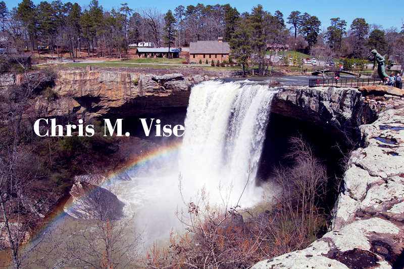
Noccalula Falls with a rainbow in its spray. Photo by me, March 2011.

Noccalula Falls is located in a park in the city of Gadsden, Alabama. It is said to be named after a Native American Indian princess but there is no historical evidence for such a person. It is a stunning waterfall to behold as the water plunges 90 feet over the rock edge. If you go at the right time you might capture a rainbow in the water spray at the base.
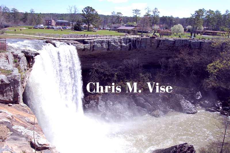
Photo by me, March 2011.

Black Creek is the source of the water for Noccalula Falls. As with any waterfall rainfall is going to be the determining factor as to how dramatic the water flow is going to be. I find that in the south the best times to go are in the winter and early spring when rainfall is more abundant.

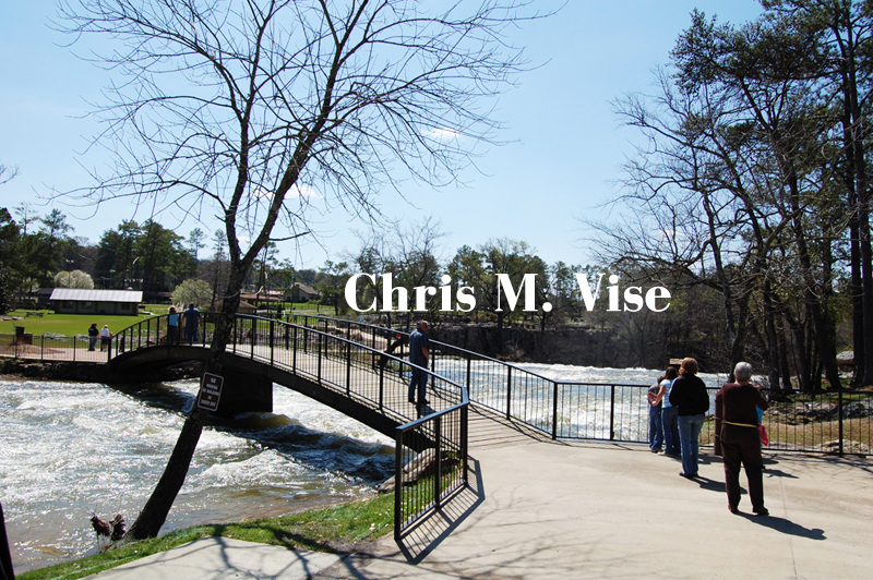
Photo by me, March 2011.

This park is nicely done with a bridge over Black Creek right at the edge of the waterfall so you get a nice view and feel the intensity of the water rushing underneath you.

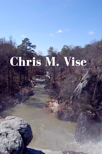
Photo by me, March 2011.

This is looking right over the precipice of the falls. There are massive boulders below and quite of bit of spray as Black Creek continues on through the hills of northeast Alabama.

In addition to the waterfall this park offers camping, hiking trails and a fort. Parking is free.

Wednesday, May 11, 2016

Little River Falls

Little River Falls. Photo by me, November 2007.

This is the prettiest waterfall in Alabama in my mind and it is easily accessible too. Little River Falls is located in the northeastern part of the state in the Little River Canyon National Preserve on Highway 35 between Gaylesville and Fort Payne. Out of the many natural wonders in the northern part of the state this is one I place at the top of the list.

Tuesday, May 10, 2016

Grace's High Falls

Grace's High Falls, Alabama. Photo by me, February 2008.

Fortunately for me when I visited in the dead of winter it had been a very wet start to the year. If it hadn't been so wet then I might not have seen this waterfall as it only flows over the cliff into Little River Canyon during times when there has been recent and steady rainfall.

Thursday, February 21, 2008

The Sock Capital

Fort Payne, Alabama. February 2008. Photo by me.


Recently, I was listening to All Things Considered on NPR which aired a story on the Sock Capital of the World, Fort Payne Alabama. The story told of how duty-free imports of socks had put the sock capital into decline as American factories were no longer able to compete with cheaper imported socks. Fort Payne struggled with empty mills and a faced a not so promising future. Some new industry has returned to the city of over 12,000 people but many of the 4,000 mill workers that lost jobs were forced to take lower paying jobs in the service sector. 

February 2008. Photo by me.

 
February 2008. Photo by me.

February 2008. Photo by me.

February 2008. Photo by me.

February 2008. Photo by me.

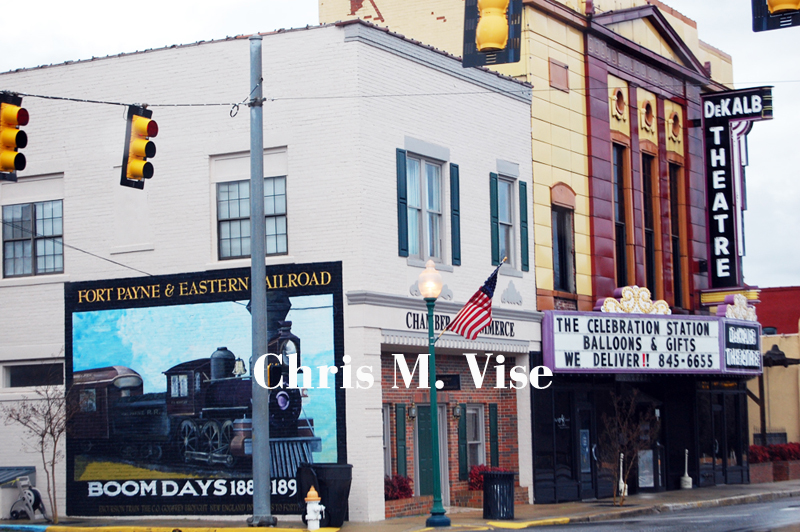
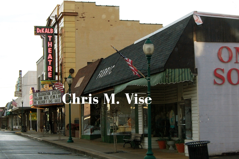
Downtown Fort Payne is a typical quaint southern small/big town with red brick buildings that indicate a more prosperous time in the not-so-distant past. Today those buildings house insurance offices, antique shops and various other small businesses. 


Fort Payne nearing I-59. February 2008. Photo by me.

I passed through the town and had an early Sunday dinner. The busiest part of Fort Payne was away from the town center and out by Interstate 59 which passes by on its way to Chattanooga or Birmingham. In that area you find the Walmart, hospital and other new chain developments you would find in most any other American town.

February 2008. Photo by me.

Fort Payne is also the hometown of the country/southern rock band Alabama that was most popular in the 1980s.

I wonder how many other Fort Payne's are scattered across this country. Towns that had one main manufacturing industry that was destroyed through the global marketplace.


Related: NPR story on Fort Payne